The Archaeology of Toxic and Hazardous Environments illustrates the use of applied technology to provide enhanced levels of data control in restricted time frames - and often, for archaeological challenges to the viability of historic preservation in dangerous settings.
Two examples of emergency rescue archaeology, one a Civil War complex under a contaminated Superfund site, the other a national monument damaged by natural disaster, illustrate the application of a range of applied technology solutions to emergency rescue archaeology in extreme settings.
Multiple categories of, overlapping - and often redundant - applied technology are discussed: all-weather field and laboratory operations, self-contained, real-time, concurrent, data control and feedback, and the use of GIS and geophysics in tandem with advanced 3D paleo-environmental modeling to target areas of archaeological sensitivity in difficult contexts.
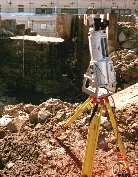
New classes of high speed non-contact 3D recording, single-camera computer-integrated photogrammetry and the first-generation of true-color 3D laser-radar (Lidar), illustrate the ability of modern archaeology to do justice to our cultural resources....to the highest standards, and without compromise to the quality, precision or adequacy of the data.
At the policy level, these strategies demonstrate the ability of modern archaeology to do justice to our dwindling culture history - even in highly dangerous, toxic, radioactive or ordnance-laced environments.
Two examples of emergency rescue archaeology, one a Civil War complex under a contaminated Superfund site, the other a national monument damaged by natural disaster, illustrate the application of a range of applied technology solutions to emergency rescue archaeology in extreme settings.
Multiple categories of, overlapping - and often redundant - applied technology are discussed: all-weather field and laboratory operations, self-contained, real-time, concurrent, data control and feedback, and the use of GIS and geophysics in tandem with advanced 3D paleo-environmental modeling to target areas of archaeological sensitivity in difficult contexts.
New classes of high speed non-contact 3D recording, single-camera computer-integrated photogrammetry and the first-generation of true-color 3D laser-radar (Lidar), illustrate the ability of modern archaeology to do justice to our cultural resources....to the highest standards, and without compromise to the quality, precision or adequacy of the data.
At the policy level, these strategies demonstrate the ability of modern archaeology to do justice to our dwindling culture history - even in highly dangerous, toxic, radioactive or ordnance-laced environments.
Chapter Abstract:
PHOTO: © 2007 JOEL W. GROSSMAN, Ph.D.
Double click Photo to see LIDAR Scan
GROSSMAN, JOEL W.
Inter-Regional Studies/ Archaeology of Toxic and Hazardous Environments. In Pearsall, D (ed). Encyclopedia of Archaeology, Elsevier/Academic Press, Oxford, England (Revised release date: October 27, 2007)
Inter-Regional Studies/ Archaeology of Toxic and Hazardous Environments. In Pearsall, D (ed). Encyclopedia of Archaeology, Elsevier/Academic Press, Oxford, England (Revised release date: October 27, 2007)