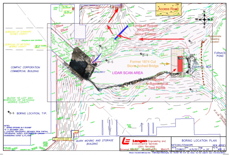
2007 Note: Re: Archaeological Mitigation Plan - Grossman 2004. Before recording unavoidable impact areas, massive bypass channel mitigation plan was reengineered from being a large cut through the Civil War foundry site, to a non-impacting series of environmentally passive overland syphon pipes to divert the river without cutting through the National Register complex bordering both banks, sheeting moved upriver and machine cuts stayed above historic elements (Grossman 2002, 2004, Fig. 10).
[ff-Report] [ff_Flood] [ff_DEM_Stanhope] [ff_1828_Map] [ff-3DGIS_GDavis] [ff-Base_Map] [ff-Haul_Road_Map] [ff-1858_gismap] [ff-Foundry_Recon] [ff-Foundry_gis] [FF-CAD_plan] [ff-Jeff-Joel] [ff_Wintersite]
[ff-Dewatering] [ff-Deicing] [ff-Draining] [ff_EDM-GPS] [ff-LIDAR] [ff-LidarScan1] [ff-LidarScan2] [ff-LidarScan3] [ff-RolleDmProfile] [ff-Rollie-Lidar]
[ff-Dewatering] [ff-Deicing] [ff-Draining] [ff_EDM-GPS] [ff-LIDAR] [ff-LidarScan1] [ff-LidarScan2] [ff-LidarScan3] [ff-RolleDmProfile] [ff-Rollie-Lidar]
To LIDAR Slideshow
To LIDAR Videos
[Raritan Landing -1979] [Broad St. - 1984] [Fort Edward - 1986] [Loiza - 1987] [Superfund at West Point Foundry -1989-1995] [Early LIDAR in Albany-1999]
[Meadowlands GIS Plan - 1992 - 2006] [Mitigation Plan - Furnace Falls 2002 ] [Furnace Falls - Color LIDAR -2004]
[Meadowlands GIS Plan - 1992 - 2006] [Mitigation Plan - Furnace Falls 2002 ] [Furnace Falls - Color LIDAR -2004]