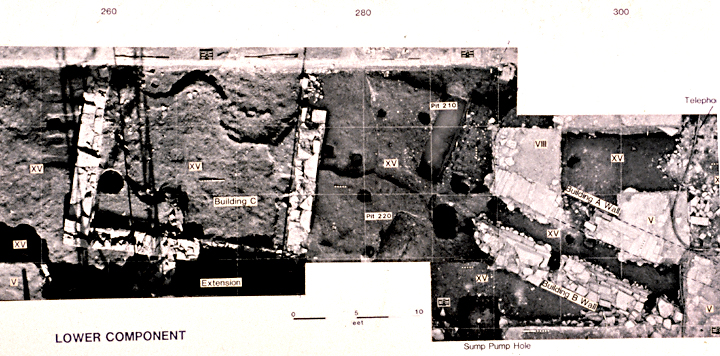
1979 Photomosaic composit compiled from Overhead Bipod flat-field, or metric, photos seamed together to form a precise geospatial record and base map of the excavated 1730 Colonial surface discovered under three feet of shale fill at Raritan Landing, New Jersey. (Grossman 1980, 1982, 2003, 2007).
Photomosaic of Multiple Overhead Bi-Pod Metric Photographs of the post-1730 Buried Surface at Raritan Landing
[Raritan Landing -1979] [Broad St. - 1984] [Fort Edward - 1986] [Loiza - 1987] [Superfund at West Point Foundry -1989-1995] [Early LIDAR in Albany-1999]
[Meadowlands GIS Plan - 1992 - 2006] [Mitigation Plan - Furnace Falls 2002 ] [Furnace Dalls - Color LIDAR -2004]
[Meadowlands GIS Plan - 1992 - 2006] [Mitigation Plan - Furnace Falls 2002 ] [Furnace Dalls - Color LIDAR -2004]