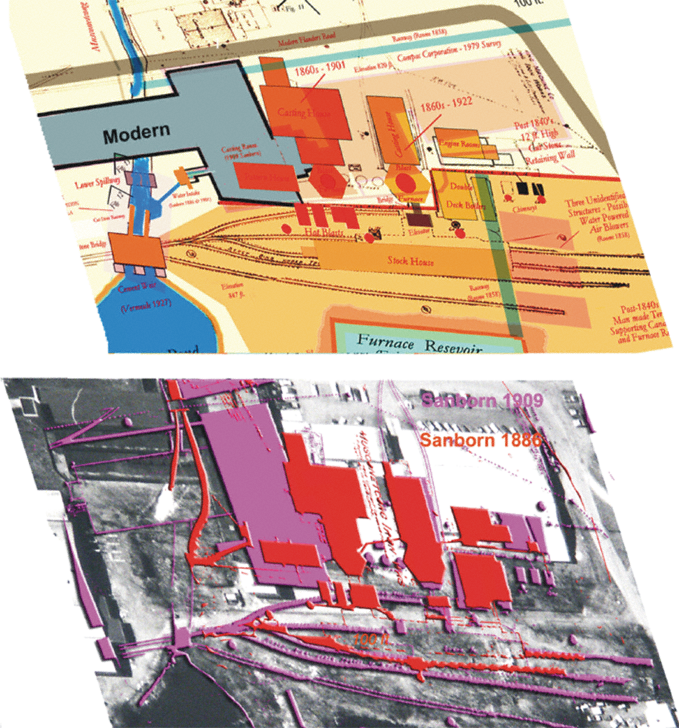
Intensive use of historic GIS ,or Historic Impact Analsys, to remotely identify buried Civil War-era hitoric archaeological remains that could be threatened by planned emergency dam remediation. 19th Century Sanborn insurance Maps were georreferenced and scaled to modern air photo coverage of the project site. These historic composits in turn served to target the location of two endangered Civil War-era historic structural features. Histoirc GIS and reprojection and graphics by Joel W. Grossman, Ph.D. (See Grossman 2007b)
[ff-Report] [ff_Flood] [ff_DEM_Stanhope] [ff_1828_Map] [ff-3DGIS_GDavis] [ff-Base_Map] [ff-Haul_Road_Map] [ff-1858_gismap] [ff-Foundry_Recon] [ff-Foundry_gis] [FF-CAD_plan] [ff-Jeff-Joel]
[ff_Wintersite] [ff-Dewatering] [ff-Deicing] [ff-Draining] [ff_EDM-GPS] [ff-LIDAR] [ff-LidarScan1] [ff-LidarScan2] [ff-LidarScan3] [ff-RolleDmProfile] [ff-Rollie-Lidar]
[ff_Wintersite] [ff-Dewatering] [ff-Deicing] [ff-Draining] [ff_EDM-GPS] [ff-LIDAR] [ff-LidarScan1] [ff-LidarScan2] [ff-LidarScan3] [ff-RolleDmProfile] [ff-Rollie-Lidar]
To LIDAR Slideshow
To LIDAR Videos
[Raritan Landing -1979] [Broad St. - 1984] [Fort Edward - 1986] [Loiza - 1987] [Superfund at West Point Foundry -1989-1995] [Early LIDAR in Albany-1999]
[Meadowlands GIS Plan - 1992 - 2006] [Mitigation Plan - Furnace Falls 2002 ] [Furnace Falls - Color LIDAR -2004]
[Meadowlands GIS Plan - 1992 - 2006] [Mitigation Plan - Furnace Falls 2002 ] [Furnace Falls - Color LIDAR -2004]